The globalisation of marine coastal ecoregions caused by global shipping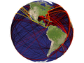 The figures and calculations shown here are based on a scientific publication recently published in
Ecology Letters.
The citation is provided below. Most of the work was done by Dr. Hanno Seebens
and Prof. Bernd Blasius from the group of Mathematical Modelling at the ICBM.
The figures and calculations shown here are based on a scientific publication recently published in
Ecology Letters.
The citation is provided below. Most of the work was done by Dr. Hanno Seebens
and Prof. Bernd Blasius from the group of Mathematical Modelling at the ICBM.
The ongoing increase of worldwide cargo transport as a consequence of globalisation has unintentionally accelarated the global spread of species. Species are hitchhiking on cargo ships as stowaways in ballast water, attached on hulls or hidden in containers. The exchange of commodoties around the world enabled species to reach habitats which they would have never been able to reach by their own migratory abilities. Most of the newly introduced species do not pose any harm to the recipient ecoregion but some repress native species, alter ecosystem functions or change the food web. These invasive species are now recognized as one of the greatest threats to biodiversity (Sala et al. 2000). 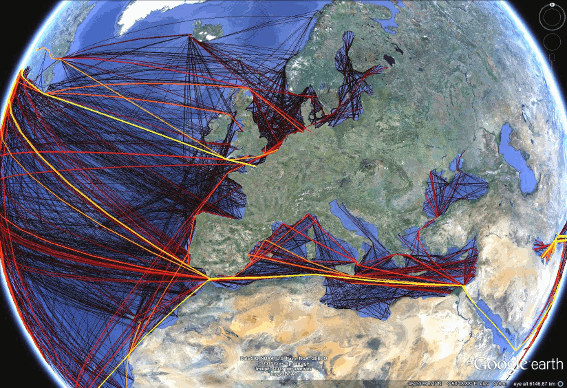 In a scientific study published in Ecology Letters a model
is presented which integrates global shipping activities, ballast water releases, environmental
heterogeneity and biogeography to calculate the invasion probability caused by a single ship entering a port.
The invasion probabilities can be aggregated to different to different spatial scales to identify the
highways and the hot spots of marine
bioinvasion caused by ballast water releases. The model also allows the determination of the source regions from where a non-native species is likely
to arrive. The study which describes the
model in detail including possible model extensions and a thorough discussion can be found here.
In a scientific study published in Ecology Letters a model
is presented which integrates global shipping activities, ballast water releases, environmental
heterogeneity and biogeography to calculate the invasion probability caused by a single ship entering a port.
The invasion probabilities can be aggregated to different to different spatial scales to identify the
highways and the hot spots of marine
bioinvasion caused by ballast water releases. The model also allows the determination of the source regions from where a non-native species is likely
to arrive. The study which describes the
model in detail including possible model extensions and a thorough discussion can be found here.
Each time a ship enters a port, a probability of invasion is calculated. That is, the probability is calculated that this ship releases a viable, non-native species able to establish a population in the port of call. A potentially invasive species may originate from any port previously called by the ship. Thus, the model takes the full history of the ship travel into account including all ports previously launched by the ship. The model consists of three independent probabilities each describing one important step of the invasion process. For each ship movement (1) the probability to get a non-native species, (2) the probability of introduction and (3) the probability of establishment is calculated. Their product gives the invasion probability for the specific ship movement. All invasion probabilities between previously launched ports and the current one are then combined to integrate the full ship trajectory. The study took advantage of a huge data set of global ship movements obtained from Lloyd's Register Fairplay (www.fairplay.co.uk/). The data were collected from the Automatic Indentification System which automatically reports when a ship equipped with this system enters the range of a transponder. The data used in this study were compiled from 1469 ports and comprise nearly 3 Mio. ship movements of 32.000 ships of any type and any size above 10GT during 2007-2008. These data are combined to the network of global ship movements. A subset of these data is analysed in more detail in Kaluza et al. (2010). Citation: Seebens, H., Gastner, M. & Blasius, B. (2013): The risk of marine bioinvasion caused by global shipping. Ecology Letters (2013), 16(6): 782–790. The website was created by Hanno Seebens. Contents can be used with proper citation and permission. |